Subtropical System Threatens East Coast with High Winds and Coastal Flooding as NHC Monitors Development
October 21, 2026· Albina Bieci
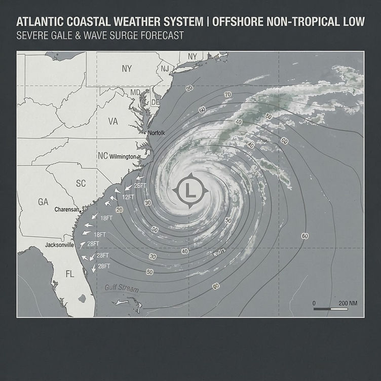
ORLANDO, Fla. — The National Hurricane Center issued an advisory on October 21, 2026, identifying a non-tropical area of low pressure positioned just off the Carolina coast as a system worth monitoring for subtropical development over the coming days. The agency placed the probability of development at 40 percent as the disturbance was expected to track northeast and away from the United States later in the week. Florida meteorologists at the FOX 35 Storm Team confirmed the state is not expected to face a direct threat from the system, though the broader East Coast faces legitimate hazards regardless of whether formal subtropical status is ever assigned.
If the low does organize sufficiently, it would be designated Subtropical Storm Josephine — the next name on the 2026 Atlantic tropical storm list.
Key Facts at a Glance
- Source: National Hurricane Center advisory, October 21, 2026
- System type: Non-tropical area of low pressure
- Current location: Off the Carolina coast
- Development probability: 40 percent (subtropical storm)
- Potential name if organized: Subtropical Storm Josephine
- Expected hazards: High winds, dangerous surf, coastal flooding along U.S. East Coast
- Florida outlook: No direct threat anticipated; system expected to track northeast
- Status of the following details: Pending — exact track, timing of hazard onset, affected coastal counties, storm surge estimates
What We Know
The National Hurricane Center's advisory, published early on October 21, described a disorganized but moisture-laden low sitting near the Carolina coastline. Subtropical systems differ from classic tropical cyclones in that they draw energy from both atmospheric and oceanic sources and can maintain a broader, less symmetric structure. They are nonetheless capable of generating sustained dangerous winds and significant wave heights, particularly in coastal zones already sensitized by prior storm activity or elevated sea levels.
According to the NHC, the system carries a 40 percent probability of developing into a subtropical storm within the next several days. That figure places it in a category the agency considers worth watching but not yet imminent. The NHC uses a five-day formation probability scale in its Tropical Weather Outlook, and a 40 percent figure reflects genuine meteorological uncertainty — the system could consolidate rapidly under favorable atmospheric conditions or remain disorganized and dissipate without ever receiving a name.
What is confirmed regardless of development: the low is already producing effects. High winds, dangerous surf, and coastal flooding are expected along portions of the U.S. East Coast as the disturbance moves through. The FOX 35 Storm Team, citing NHC data, reported that these hazards will materialize whether or not the system reaches subtropical classification. Coastal residents from the Carolinas northward should treat the incoming conditions as a genuine weather event, not merely a tracking exercise.
For Florida, the meteorological consensus is reassuring. The low is anticipated to track northeast, pulling it away from the peninsula rather than toward it. However, marine interests, offshore platforms, and coastal communities in northeast Florida may still observe elevated seas and rip current risk as the outer circulation passes at distance. Active rip current advisories were already in effect for Coastal Flagler County and Coastal Volusia County as of the time of this report, per weather alert data associated with the FOX 35 broadcast area.
What Has Not Been Released
Several details remain unconfirmed or pending at the time of publication. The NHC advisory did not specify exact projected landfall risk areas for wave and surge impacts beyond general East Coast language. No watches or warnings had been issued for inland or coastal communities as of the morning of October 21. Precise storm surge projections, if any, have not been released publicly in association with this system. The track forecast cone — a standard NHC product for named systems — has not yet been published because the system has not achieved tropical or subtropical designation.
The timeline for any potential subtropical organization is also unspecified. The NHC's language of "over the next few days" is deliberately broad and reflects genuine model disagreement. Readers and emergency managers should monitor the NHC Tropical Weather Outlook directly for updated probability figures, which are typically refreshed multiple times daily during active monitoring periods.
Additionally, whether any coastal counties along the Carolinas, Virginia, or the Mid-Atlantic have issued formal coastal flood advisories in response to this system is unknown at the time of publication. Those details are expected to emerge as the system's behavior becomes clearer over the next 24 to 48 hours.
Technical Analysis: Storm Impairment, Fire Watch Obligations, and Property Risk
From a loss-prevention standpoint, subtropical and tropical systems generate a category of risk that property managers, facility operators, and construction sites often underestimate until it materializes: the disruption of active fire suppression systems and the triggering of mandatory fire watch obligations under NFPA standards.
When a storm produces high winds, storm surge, or flooding, the results for built infrastructure often include power outages, physical damage to sprinkler piping, contamination of standpipe systems, and the partial or total impairment of fire alarm and detection networks. Under NFPA 25, the Standard for the Inspection, Testing, and Maintenance of Water-Based Fire Protection Systems, any impairment to a water-based suppression system — whether planned or caused by an external event such as a storm — requires the property owner or designated impairment coordinator to implement an emergency impairment program. That program includes notifying the authority having jurisdiction, the insurance carrier, and the fire department, and it requires continuous fire watch patrols in the affected areas until the system is restored to full service.
NFPA 72, the National Fire Alarm and Signaling Code, establishes parallel requirements when fire alarm and detection systems are rendered inoperable. Section 10.19 of the standard addresses impaired equipment and prescribes that an owner must implement a fire watch whenever the fire alarm system serving a building or portion of a building is out of service for more than four hours in a 24-hour period. Storm damage frequently produces exactly this scenario — a power surge trips an alarm panel, a flooded conduit shorts detection wiring, or wind damage to a building envelope compromises heat or smoke detection in exposed zones.
For properties under active construction or hot-work programs on the East Coast, NFPA 51B, Standard for Fire Prevention During Welding, Cutting, and Other Hot Work, adds an additional layer. Hot work permits are typically suspended during active storm conditions, but the one-hour fire watch requirement following any hot work activity remains in force, and pre-storm shutdowns should include a formal verification that all hot work areas have been properly cleared and monitored.
Coastal flooding introduces additional complications for below-grade fire pump rooms and sprinkler system risers. Flood intrusion can damage pump controllers, submerge electrical panels, and introduce debris into system piping, all of which require inspection and testing before the system can be returned to service. Until a licensed fire protection contractor clears the system and submits documentation to the AHJ, fire watch obligations remain active under both NFPA 25 and applicable local fire codes.
Property managers and facility directors along the East Coast should use the development window — while the NHC probability remains at 40 percent and the system has not yet organized — to confirm their impairment response plans, verify that fire watch contractor agreements are current, and brief security personnel on patrol protocols for post-storm inspections.
Local Context: East Coast Coastal Communities and Florida's Preparedness Position
Florida's position outside the direct threat zone does not entirely remove the state from storm-related operational concerns. Coastal counties in northeast Florida, including Flagler and Volusia, are already under active rip current advisories. Marina operators, beachfront hotels, and coastal construction projects in those counties should evaluate whether elevated surf conditions affect any active fire suppression systems or temporary structures where fire watch obligations may already be in place.
For communities along the Carolina coast, Virginia Beach, and the Delmarva Peninsula — the areas most likely to experience the brunt of this system's wind and surge effects — the timing is particularly consequential. The late-October period aligns with active construction seasons in many of those markets, and temporary structures, scaffolding, and partially enclosed buildings present elevated fire risk when detection and suppression systems are not yet fully commissioned.
USPA Nationwide Security provides fire watch and security services along the East Coast, including in coastal and construction-active markets. For properties in the Carolinas, Mid-Atlantic, and Florida coastal zones that need to activate or confirm fire watch coverage before this system makes its closest approach, contact USPA at (800) 214-1448.
For facilities specifically in the coastal Florida market, USPA maintains local service infrastructure. Properties in the region can learn more about available fire watch services and security guard services through USPA's regional pages, and the company's national emergency fire watch team is available around the clock for storm-driven impairment activations.
Property Obligations Going Forward
Assuming the system follows the NHC's projected northeast track, East Coast property owners and facility managers face a near-term checklist that extends beyond storm prep into post-event fire and life safety compliance.
First, any property that experiences physical damage to fire suppression piping, alarm panels, detection devices, or fire pump infrastructure must immediately notify its AHJ and insurance carrier and initiate a formal impairment record as required by NFPA 25. This is not discretionary — the standard is clear that impairment coordinators bear responsibility for initiating these notifications promptly.
Second, fire watch patrols must begin immediately upon confirmation that a fire alarm or suppression system is out of service and cannot be restored within the four-hour NFPA 72 window. The patrol must be continuous, must cover all areas protected by the impaired system, and must be performed by personnel who understand the patrol requirements and documentation obligations. A fire watch log is a legal document and may be reviewed by the AHJ, insurance adjusters, or litigation counsel in the event of a subsequent fire.
Third, construction sites that resumed hot work before the storm must verify that their one-hour post-work fire watch has been properly closed out and logged. Debris and combustible materials displaced by wind create new ignition risks in areas that may have been considered cleared before the storm.
Fourth, facilities should schedule a licensed fire protection contractor inspection of water-based systems before returning them to service after flood intrusion. A system that appears operational may have debris in sprinkler heads, compromised pressure, or damaged components that would cause it to fail at the moment it is needed.
Fifth, facilities that have sustained structural damage should assess whether the physical integrity of the building now places occupants at risk in ways that a functioning suppression system would not fully address. In those cases, a trained security presence — separate from the fire watch function — may be warranted to manage access, document conditions, and coordinate with emergency services.
Sources and Open Questions
This report is based on the National Hurricane Center's Tropical Weather Outlook advisory published October 21, 2026, and meteorological reporting by FOX 35 Orlando's Storm Team. Technical analysis of fire watch obligations references NFPA 25, NFPA 72, and NFPA 51B, all published standards of the National Fire Protection Association.
Open questions as of the time of publication include:
- Whether the system will achieve subtropical status and receive the name Josephine
- The precise track and timing of hazardous conditions along the East Coast
- Whether any coastal counties have issued formal flood or wind advisories in response
- Storm surge projections, if any, for affected areas
- The extent to which the system's outer circulation will affect northeast Florida marine and coastal conditions beyond existing rip current advisories
This article will be updated as the NHC issues revised probability figures and as additional detail becomes available from local emergency management agencies.
For fire watch or security coverage before, during, or after this storm system, contact USPA Nationwide Security at (800) 214-1448 or visit uspasecurity.com/emergency-fire-watch.
Related Reading
Questions about fire watch, executive protection or guard coverage for your property? Request a quote or call our dispatch line.
More from the blog


Breaking News
Three-Alarm Fire at Morristown Restaurant Triggers Apartment Evacuations on Spring Street
A three-alarm fire broke out Monday evening at Mega BBQ on Spring Street in Morristown, New Jersey, forcing the evacuation of residential tenants above the restaurant and drawing mutual-aid companies from three neighboring communities. No injuries were reported. Investigators have not yet confirmed a cause, though preliminary indications point to an exhaust chute near the restaurant's stove.

Breaking News
Four Units Damaged in Overnight Apartment Fire Near Loop 410 and Starcrest on San Antonio's Northeast Side
Two units were damaged by fire and two by water in an overnight apartment fire near Loop 410 and Starcrest Drive on San Antonio's Northeast Side on Oct. 5. No injuries were reported, and the cause is under investigation by the San Antonio Fire Department.

Breaking News
One Dead, Two Injured in Second-Floor Fire at Primavera Square Apartments in Bensalem; Victim Identified as James Nugent
A fire in a second-floor apartment at Primavera Square Apartments in Bensalem's Andalusia section on Saturday, Oct. 17 killed James Nugent and injured two others, with six units affected. The cause of the fire remains under investigation by Bensalem Fire Rescue and police detectives.